Tuesday, 29 March 2011

Canoeing Learning Curve

I'm going to risk sounding painfully smug here, but I have recently been handed an opportunity that I'm finding hard to believe is also actual work. I'm taking part as an assistant leader in some Duke of Edinburgh Silver award expeditions, not on foot, but in canoes. I'm even getting the chance to come out with the team on a couple of training days in Ayrshire. Regular readers will know that I'm partial to getting out in my sea kayak on a nice day, but open boats are an unknown quantity to me and I'm really enjoying the challenge of learning new skills.

 Andy McNamara, Otter's Tail Adventures

The group is being coached by Andy McNamara from Otter's Tail Adventures, who runs canoeing expeditions throughout Scotland.  Just watching Andy pootling about in his boat is a lesson in paddle strokes, (he wears a canoe like a dancer wears ballet shoes) and his patient approach means that after a couple of days with the group, we are all starting to get the hang of it (even me). 
Last Sunday the weather was clear, calm and mild so we ventured out for a little coastal paddling, putting in at Doonfoot, Ayr and heading south past the Heads of Ayr to Culzean Bay. 

Students or Pirates? Ailsa Craig is in the distance (thanks Andy for this photo).

We saw plenty of wildlife on the way round the coast, including shags, eiders, shelduck, razorbills, and even a small flock of sandpipers newly arrived at Dunure.  It was great for me to explore a new bit of coast (which I can see from home) and also to enjoy some different views of Arran. Can't wait till the first exped at the beginning of June!

Fantastic views of Arran just across the water. 

Friday, 25 March 2011

A' Chir Rock

Winter must be over properly (in my head) as this week I have started thinking about rock again. It was a gorgeous day today and this morning we were so excited about getting out in the hills we practically bounced down Glen Rosa. It's still quite cold in the wind, too cold for a softy like me to stand around on a cold belay, so we opted for the A' Chir Ridge, an easy rock climb or hard scramble that hangs between Beinn Tarsuinn and Cir Mhor.

Looking up Glen Rosa towards Cir Mhor. 

The South Face of Cir Mhor.  The classic route Souwester Slabs (v diff) takes the easiest line up this face. 

On the Bealach between Cir Mhor and A' Chir


 Looking towards the impenetrable face of the first major difficulties.  The route involves beaching yourself on a shelf that runs diagonally up the face. 

The comment at this point was "Well I'm not caving fit".....

Out of the trench and back up on the ridge. There is a small step across the void here. 

Fabulous views across Glen Rosa to Goat Fell.

Looking back to Cir Mhor and over The Saddle from the slopes of Beinn a Chliabhain on our way back down to the Glen.


Thursday, 24 March 2011

Walking on the Wild Side: Magical Machrie Moor

This is the second of a series of articles that I am writing for the Voice for Arran about Walking and Wildlife on Arran.


 I love getting to know the layers of a landscape. For me, walking on Arran is an ongoing study in the composition and history of a place. Footpaths and structures are knitted into the land like bones and blood vessels. The walk from roadside to Machrie Stone Circles, for example, passes through five thousand years of human endeavour, lovingly erected from the rock of ages in just a couple of miles of rutted farm track.

My favourite time to arrive at the moor is late in the day as the sun’s rays are at a low angle. I wait until the car park has begun to empty, and cross the stile opposite. The track to the Stones cuts across meadows and skirts the wooded river bank above the Machrie Water. The track shortly bends away from the river and I pass the mysterious “Moss Farm Road Cairn”. This cairn looks for all the world like a stone circle, but is believed to be a kerbed cairn, encircled by a rim of lumpy boulders marking its outer edge.

The track rises through rough pasture and sweet gorse, until I’m at the fringes of the moor. I briefly turn off the path, to pay a visit to a favourite place, a hut circle some twenty feet in diameter, hidden amongst the soft rushes and heather. This was once the dwelling place for a Bronze Age family. Similar structures have been excavated all over Britain. The inhabitants herded their animals and steadfastly tilled the land. Theirs was a time of great cultural flowering, when stone monuments sprung up all over the country. Populations were expanding, settling new places now abandoned even by modern farmers. Today, a raised ring of rushes marks all that is left of their home. In summer, spotted heath orchids grow proudly in the boggy centre of the hut where I imagine there was once a hearth.

Returning to the track, it isn’t long before I reach the first of the stone circles, a double ring of granite boulders. Sixty five million years ago, the rock swirled and heaved in the bosom of a huge volcano. The magma cooled, and the outer crust of lava was slowly eroded to reveal the granite core. Boulders were dragged down from the hills by ancient glaciers, which in turn faltered and melted more than ten thousand years ago, leaving rocks marooned in the landscape, ready for humans to trundle the last few metres into place. This circle is known as Fingal’s Cauldron Seat, and it is said that the celtic giant tethered his great dog Bran to one of the boulders while he boiled water for his supper. The derelict buildings of Moss Farm sit opposite. The crumbling walls are home to starlings and swallows in the summer.

I go through the gate and on to the moor itself. The setting sun is reflected by the orange glow of the sandstone pillars that stand erect like bare tree trunks. The circle builders chose a combination of granite boulders and quarried sandstone. Where sandstone was used, there is a sense that this was with a purpose, now hidden. Six circles have been discovered and of these, four include sandstone as well as granite. All have been excavated, with varying degrees of care. The most recent excavations by Alison Haggarty were published in 1991. It was Haggarty who made the last circle discovery, a sixth secret buried beneath the peat. Who knows if there are more?

Today the moor is a wet and inhospitable place for humans. Crisscrossed by ditches, dense birch and willow scrub, and pocked with hidden mires, the moor is home to fearsome adders and birds of prey. Lines of broken fences confirm sporadic sheep grazing, but the moor feels like a wild place.

It was not always like this. The land of the circle builders used to be rich and ripe. Below the peat and beneath the stones have been found the marks of ploughs etched into an old and fertile soil. Older still are the posts and pits that tell the true age of the site. Haggarty’s excavations revealed that the first circles on the moor were wrought of timber four and a half thousand years ago. Even earlier are fragments of pottery and rough pits left behind by early pastoralists, Neolithic people living five thousand years ago. The story of the moor is of a thousand years of population growth and intensification. Settlements sprang up, and with them sacred places for people to gather together, built first of wood, and then stone. The site reached its zenith some time in the beginning of the second millennium BC, when the people carefully buried the cremated remains of their kin inside the circles with precious implements and hand crafted earthenware.

Eventually, the climate began to sour and the moor became a less friendly place. The weather deteriorated and the peat grew and deepened. The people retreated to the margins of the land, farming the fertile strip between coast and hill. The moor was left alone and the black bog took hold, in places reaching a depth of three metres.

I sit with my back to sun-warmed sandstone and try to imagine how the moor would have felt all those years ago. I picture a settled scene, small hamlets surrounding an area of common land, quilted with a patchwork of crops and pasture. Wooden stakes mark out animal enclosures, and circles of stone stand neatly in the centre of a hive of activity. For a moment I can hear the homely songs of the farmers, but they are lost in the fluting calls of curlews carried on the wind. Machrie moor still brims with life, but it belongs to wilder inhabitants now.
Things to look out for on Machrie Moor:
  • Moorland birds including curlew, wheatear, meadow pipit, hen harrier, buzzard, short eared owl and kestrel
  • A hole in a boulder in the first circle where Fingal is said to have tethered his dog, Bran.
  • Two half-finished mill stones, fashioned in recent centuries from granite standing stones.
Take Care:
  • The moor is a working sheep farm. Keep dogs on a lead at all times.
  • Stick to the main path to avoid getting bogged down or disturbing wildlife.

Monday, 14 March 2011

Goatfell half hour photo experiment

Todays weather wasn't really the sort that inspires you to climb a mountain that you have been up countless times before, but in the spirit of getting my fitness back after megaflu, I thought it would be a good idea to bundle up Goatfell this afternoon and give the lungs some air. To make it more interesting, and to force myself to take photos on a walk that I do all the time on a day when there wasn't much to photograph, I set myself some rules. Stop every half hour, and take a photo. Doesn't matter what it is, but try and find something interesting. I lost the game immediately, because I forgot to take a photo at the start. Here are the rest:

 
1420: Half an hour in, and this is a photo of Maol Don, taken at a height of about 300m. Great views of soaring Buzzards here.

1450: I am at 500m, in the snow now, and admiring the sun trying to force its way through the clag. 

1520: 650m. The mist is pretty oppressive now so I concentrate on things nearer.  This is prostrate juniper- a creeping form of Juniper found on sunny south facing slopes above 500m. 

1550: 750m and climbing.  I'm wading through deep snow drifts here looking for the path!

1610: 874m and I cheated a bit here as this is not my half hour picture, but we all like summit photos. 

1620: 800m Still not much of a view, so here is a close up of some crusty ice feathers forming on the heather. 

1650: 600m. This ring of ice fell off the bottom of my trekking pole. 

1720: 350m At last! A view. :-)

1750: 80m Final photo is very disappointing... Apologies for the anticlimax!


Thursday, 3 March 2011

Spring on Beinn a'Chaorainn

Monday last I abandoned my poor partner in crime to his flu ridden campervan-fest and met up with Ben Keen from Shearwater Adventure for a day in the winter hills. The east ridge of Beinn a'Chaorainn was our objective for the day and the weather forecast couldn't have been better.

We began with a quick bushwack through the forest on the west side of the Allt na h Uamha, before emerging in the glen and joining a forest track that took us through a second plantation. Before long we were bashing up the heathery hillsides towards the base of the ridge which was looking alarmingly devoid of snow as we approached.

Knowing that the ridge is also a popular summer scramble we decided to go for it, whatever the condition- and were pleased to find when we got to the toe of the buttress that the north side of the ridge was still very snowy and a series of grooves led up towards the snowy crest higher up.  Ben and I decided that this was the ideal time to practice our winter ML techniques so we dispensed with climbing harnesses, tied the rope round our waists, and Ben shot off up the first snowy groove.

In five short pitches we made the crest, and took in coils. It was then a quick bundle up a series of short but fun rock steps before we were level with the curly cornices on the plateau on either side of the ridge. There was some avalanche debris and evidence of cornice collapse during the recent thaw.


The ridge is graded I/II but in the firm snow and dry conditions on the day it was a lot easier.  It is a popular choice in avalanche conditions, and I imagine that when buried it is quite challenging and for safety reasons teams will stick to the crest all the way.  I owe Wally a day on this route, so expect I will be back before long to see what it is like under deeper snow.

Meanwhile, Ben and I had topped out and it was barely even lunch time.  The sun was shining, I was getting my first tan of the year, and the summit of Creag Meagaidh was winking at us from across the glen. We had lunch on the summit of Meagaidh, and from that vantage, there were great views of Beinn a Chaorainn, which was showing its more wintery side. The East Ridge is the well defined central diagonal line in the picture.


Descent was a simple matter of following the eastern arm of the horseshoe around the glen back down to the Allt na h Uamha and a reasonable path to the road on the east side of the burn.

I have since paid for my desertion with a bout of the same flu that Wally was suffering with.  Well deserved, but no regrets!

Wednesday, 2 March 2011

Silver Sands of Morar

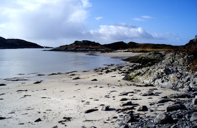
I'm just back from a great couple of days on the mainland. The plan had been to spend a couple of days in the hills with Wally, and to meet up with Ben for one of those days.  The best laid plans were scuppered by poor Wally getting laid low with "manflu" so on the first day we went to the beach instead (a cure for most ills). As I'm now languishing at home with the same virus (or at least the female version) I will just post a few nice photos of the beach for starters. (I promise that when the head clears I'll write up my day with Ben on the East Ridge of Beinn A Chaorainn, as it was a stunning day!)
The excellent Walkhighlands site features the relatively easy walk to the sands of Morar.