Saturday, 31 July 2010

A hard paddle

What does someone who walks for a living do on her day off? Well on Wednesday I gave the legs a rest and got in my sea kayak. Wally joined me on the water, and after a look at the weather forecast and the predicted wind direction (a breezy WSW apparently), we planned a paddle from Lamlash to North Sannox, which should have been a straightforward trip, of about 12 miles, with a following wind.....


It all started benignly enough.  Lamlash bay was looking glassy as we put in on the beach by the village green and we enjoyed a gentle paddle through the No Take Zone down towards Clauchlands Point.


As we turned North towards Brodick, the wind swung round to a Northerly too. We figured it was getting funneled round the hills of Dunn Fhionn and put our heads down for a steady paddle into the wind to Brodick Bay.


We paused to let the Caley Isles in, and finding the wind quite strong in the Bay hugged the shore until almost at the pier, and then set out across the bay surrounded by whitecaps. It was at this point I stopped taking photos- things got quite splashy and I'm not sure that my camera likes salt water much. It wasn't all bad though, we were surrounded by manx shearwaters who zipped backwards and forwards, skimming the waves with their narrow wings.

We were also treated to views of inquisitive grey seals, who followed our boats from Brodick to Corrie, but my fantasies about spotting basking sharks in glassy water were definately not going to come true.  The wind did not return to its friendly WSW position but kept blasting down the coast from the North. From Corrie onwards it became a matter of will power.  The road hugs the shore at this point and it would have been very easy to get out an hitch a lift up to North Sannox to fetch the van from where we had left it waiting.  Knowing that escape was always an option, we plugged on in to the wind.  The last half mile was really really hard work!

After dragging ourselves and our boats ashore, we went for a slap up meal in the Sannox Bay Hotel.  The staff did not seem to mind our disheveled appearance and politely ignored our appalling table manners as we devoured our dinner. Normally the portions are too large at this fab place to eat- not on this occasion though!

Afterwards I was pretty sore and tired.  I certainly need to work on my stamina in a boat as headwinds happen! However, it was all in all a good day- but definitely "type 2 fun" (fun afterwards).
View this trip in OS Explore.

Tuesday, 27 July 2010

Ben Ledi

Wally and I were on the mainland at the weekend and decided to fill in a bit of a blank and visit the Trossachs. Whenever I have time on the mainland my tendancy is to head for the bigger hills so it was nice to explore the area just the other side of Glasgow for a change.
We set off late and made good time up Ben Ledi, via an easy but very steep path that heads up from the Rob Roy Way. After a fairly boring stomp up the shoulder, the mist cleared from the summit just in time for some great views and we were pleasantly surprised that the summit itself is quite interesting, with little rock outcrops surrounding the summit.

On the top, a cross stands as a memorial to Sgt Harry Lawrie of Killin MRT who died in a helicopter accident on Ben More in 1987. 

We headed off down the northern ridge, and took the eastern shoulder (Ardnandave Hill) before turning south and walking down in to Glen Stank, passing lochans and knobbly outcrops, to eventually re-join the Rob Roy Way where we found a feast of wild raspberries in time for tea. (I should point out that there is an easy path down in to Glen Stank. We didn't take it as we wanted to explore a bit further afield. Our route took us on to rough and at times complicated ground.)

Encore île de Skye

Apologies for not posting for a while.  There has been a lot of work on recently, and the weather has not been conducive to photos so I have been slacking off with the blogging! However, I have just come back from another fantastic week on Skye and have some photos here that I hope you enjoy. I also have included below a recipe for Scottish Tablet, at the request of my last group, in English and French.

Toutes mes excuses pour ne pas ecrire pendant un certain temps.  J'ai beacoup de travail et la meteo n'a pas ete bonne pour les photos donc j'ai ete paresseux avec mon blog! Cependant, je reviens d'une atyre semaine fantastique sure SKye et quelques photos ici.  J'ai aussi inclus ci-dessus une recette de Scottish Tablet, a la demande de mon dernier group, en englais et en francais.  


Loch Coruisk, Sgurr a Ghreadaidh (left) Sgurr a Mhadaidh (centre) and Bidean Druim ana Ramh. 

Ease Mor Waterfall (again- this time with Coire an Eich and Sgurr na Banachdaich behind!).

Peaks of Coire Lagan: Sgurr Alasdair and Sgurr Sgumain

Scottish Tablet: Recipe from Undiscovered Scotland. 

Ingredients:

500g/18oz granulated sugar.
60g/2oz butter.
3½ tablespoons condensed milk.
170ml/6 floz water.
Method:
1. Grease a tin.
2. Place all the ingredients in a large saucepan and heat until the butter has melted and sugar has dissolved.
3. Bring the mixture to the boil. It is important to stir continuously at this point so the mixture doesn't stick to the bottom of the pan.
4. Bring the mixture down to simmer for approximately 10 minutes. The mixture should be thick and the colour should have turned from white to caramel.
5. Take the pan from the hob and place it on a heat resistant surface for about 5 minutes.
6. After the 5 minutes beat/stir the mixture really hard. At this point it will start to set.
7. Before the mixture sets, use a wooden spoon to transfer it into the prepared tin. You will find it sets almost straight away.
8. Before it has completely set, cut the tablet into  pieces and leave it to cool and set hard for 5 minutes.
9. Take the pieces from the tin and store them in an airtight container.

Ingrédients:

500g/18oz de sucre granulé.
60g/2oz beurre.
55mls/ 3.5 cuillères à soupe de lait condensé.
170ml / 6 floz eau.
Méthode:
1. Beurrez un moule.
2. Placez tous les ingrédients dans une grande casserole et chauffer jusqu'à ce que le beurre est fondu et le sucre soit dissous.
3. Amener le mélange à ébullition. Il est importantde continuer de remuer à ce point si le mélange ne colle pas au fond de la casserole.
4. Amener le mélange jusqu'à laisser mijoter pendant environ 10 minutes. Le mélange doit être épais et la couleur devrait se sont tournés du blanc au caramel.
5. Retirer la casserole du feu et le placer sur une surface résistante à la chaleur pendant environ 5 minutes.
6. Après les 5 minutes battre et brasser le mélange vraiment dur. À ce stade, il va commencer à définir.
7. Avant le mélange jeux, utiliser une cuillère en bois pour le transférer dans le moule préparé. Vous le trouverez ensembles presque aussitôt.
8. Avant qu'il soit complètement, couper le comprimé en morceaux et laissez-la refroidir et dur pendant 5 minutes.
9. Prenez les morceaux de l'étain et de les stocker dans un récipient hermétique
.


Sunday, 20 June 2010

Isle de Skye

I often describe Skye as my "happy place" and I was delighted to spend last week working there with a group from France for Macs Adventure and Montagne Evasion. We had mixed weather, but on the whole it was dry, although there were a couple of days of heavy mist.... Photos below! Enjoy!
Je décris souvent Skye comme mon "endroit heureux" et j'ai été ravi de passer la semaine dernière en travaillant là avec un groupe francais pour Macs Adventure et Montagne Evasion. Nous avions les temps variables, mais dans l'ensemble c'était sec, bien qu'il y ait deux ou trois jours de lourd brouillard.... Photos ci-dessous! Appréciez!

View from the start of a circular walk to see the geology of the Quairaing. La vue du début d'une promenade circulaire pour voir la géologie du Quairaing.

The scramble up to The Needle a detatched pillar of crumbling basalt.
Le chemin jusqu'à l'Aiguille, une colonne de basalte s'émiettant.


The Bay of Staffin, with the mountains of Torridon behind.
La Baie de Staffin, avec les montagnes de Torridon a derrière.


At the quayside at Elgol.  Au quai à Elgol.
Oblong leaved sundew (Drosera intermedia), Loch Coruisk.

Loch Coruisk, accessible by boat from Elgol. Loch Coruisk, accessible en bateau d'Elgol.

Northern eggar moth caterpillar (Lasiocampa quercus callunae), Loch Coruisk.  
La chenille du papillon de nuit de "eggar du Nord" (Lasiocampa quercus callunae), Loch Coruisk.

 Misty view of Orbost, Waternish peninsula.
La vue brumeuse d'Orbost, la péninsule de Waternish

The Team!  
L'Équipe!

The scottish thistle.
Le chardon écossais.

It was damp! C'était l'humidité!

Eas Mor waterfall, Glenbrittle. La cascade Eas Mor, Glenbrittle.

In the mist at Coire Lagan. Dans le brouillard à Coire Laggan.

This is a photo of Coire Lagan that I took a few years ago without the mist!

C'est une photo de Coire Lagan que j'ai pris il y a quelques années sans le brouillard!

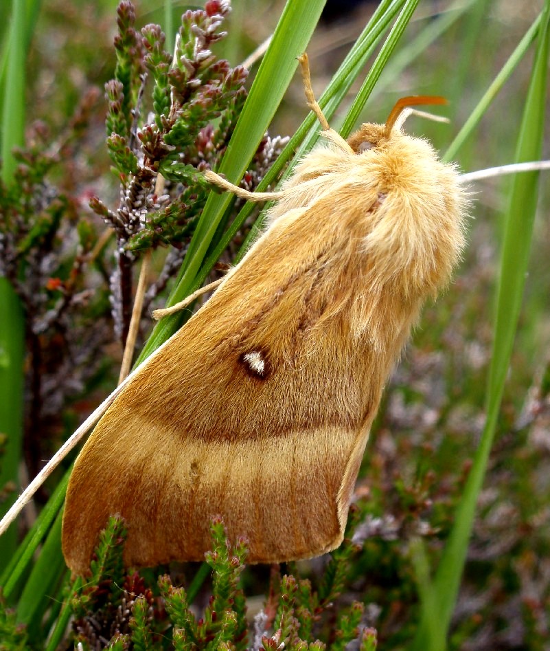
 Northern eggar moth (Lasiocampa quercus callunae), Coire Lagan.  
Le papillon de nuit de "eggar du Nord"  (Lasiocampa quercus callunae), Coire Laggan.

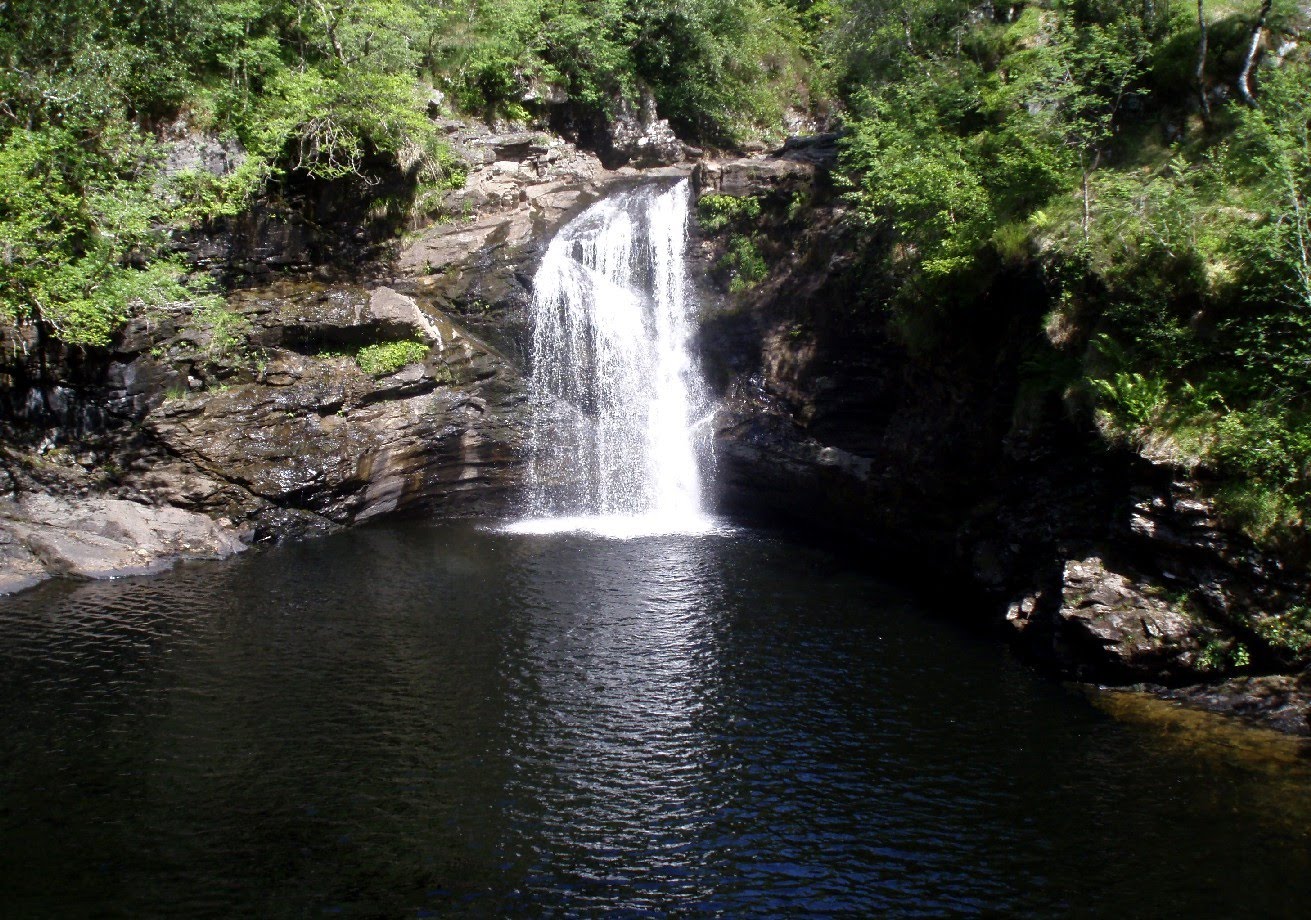
A quick stop at the Falls of Falloch on the way back to Glasgow. 
Un arrêt rapide aux Cascades de Falloch sur la voie à Glasgow.

Friday, 11 June 2010

Slovenia

We have just returned from a fantastic road trip across Europe in our new camper.  Our destination was Slovenia, one of the Alp's best kept secrets.  The country did not disappoint, with towering spires of limestone, crystal blue rivers and lakes, a gentle climate and friendly people. Its just such a shame its so far away- but perhaps that is a good thing as the area was very unspoilt and not expensive.
I'll not bore you with a blow by blow account of the trip but I hope you enjoy some photos from the holiday. We plan to go back another year- late May was a little early for the via ferrata that we were looking forward to trying.  Too much snow high up.  Our next visit will be later in the season and hopefully we will tackle some of the higher peaks in the area.

Mala Mojstovka is one of the more accessible peaks from the Vrsic Pass.

Fantastic view of Jalovec from the col by Mala Mojstovka

 
Alpine chough- common birds of the summits and high passes. 


Fire salamander- doing it's best impression of a plastic toy dinosaur.

Wild hellebores are common in the higher forest clearings and meadows.

Birds nest orchid- seems to grow in damp woodlands.

Crossing one of the many snow patches that made life difficult higher up- Vogel near Bohinj. 

Paddling an open boat on lake Bohinj.

Ladies slipper orchid, a woodland orchid with improbable flowers.

Typical rural scene- Bohinj in this case

Sava Bohinjka River

Monday, 26 April 2010

Spring on the West Highland Way

I seem to have a bit of luck with the West Highland Way. Having done it twice now, I have only had 2 days of rain out of 14 which is pretty good going for Scotland in April!  This years trip for Macsadventure, was marred at the beginning by the fact that we were missing some team members- thanks to Eyjafjallajokull, the icelandic volcano, three were stuck at home, and one unlucky person, Elaine, stranded for 5 days in Amsterdam whilst in transit from Canada!  What follows are the best images from the 95 miles from the outskirts of Glasgow to Fort William.
Day 1: Milngavie-Drymen
Laura and Jan enjoying the walk over the moor on the outskirts of Mugdock.


Day 2: Drymen to Rowardennan
Coming over Conic Hill- the first big climb of the week.


Views of Loch Lomondside between Balmaha and Rowardennan.


Day 3: Rowardennan to Inverarnan 
The group enjoying the view above the Loch on the way to Inversnaid. 


The stuning views  just keep on coming!


Wild goats roam the shores of Loch Lomond


Descending to Doune Bothy


The final view looking south from the head of Loch Lomond


The world famous Drovers Inn at Inverarnan. Home for the night and reputedly haunted! (We all slept soundly having walked 14 miles....)


Day 4: Inverarnan to Tyndrum
The Way climbs up from the loch and into the highlands. 

Fantastic views of Ben More from the hills above Crianlarich.


And some nice views of Ben More from Strathfillan.... We enjoyed a welcome ice cream at Strathfillan Farm wigwams...


The last mile is always the hardest no matter how long the day.  Here we are heading in to Tyndrum with Ben Lui in the distance.

Day 5: Tyndrum to Kingshouse
This is one of the tougher days- at 20 miles. Most of us had found our stride by this point but Elaine impressed us all by arriving from her extended stay in Amsterdam airport and marching the legs off us!
The view below is west from Victoria Bridge at Inveroran.


The stomp over Rannoch Moor has some very big views.


Day 6: Kingshouse to Kinolochleven
This was our only full day of rain. As we couldn't see a hand in front of our faces most of the day there were no photos!! Sorry. The climb up from Glencoe over the Devil's Staircase is not as hard as you would expect.  By now West Highland Way walkers are feeling fit....

Day 7: Kinlochleven to Fort William
The final push is a glorious climb up from Kinlochleven- probably the hardest climb of the week, but worth it for the views of the Pap of Glencoe and the back of the Aonach Eagach ridge. 


The Way goes through the Lairig Mor, an ancient drovers pass through the mountains
 
.
And at last we were treated to stunning views of a snow-capped Ben Nevis before the final descent in to Fort William!

You can also find information about the West Highland Way on my earlier trip report from 2009, and I recommend visiting the Macsadventure website if you are interested in doing either a guided or self guided expedition if you plan to stay in b&bs. The logistics can also then be taken care of with baggage transport between your nightly stops so that you only have to walk with a small day sack.